Fog To Sunshine PhotoWalk
I woke up early on September 1st 2018 and found out that there was a lot of fog in the outlying areas. Having never gone PhotoWalking in heavy fog before I decided that I would love to do it. My friend Jan and I had discussed doing some photography that morning and I contacted her to see if she still wanted to go. She picked me up at 7:30 and we headed for a trail that runs near and across the Grand River in the South end of Kitchener. {The photos at the beginning are somewhat mixed up as I got them mixed up when downloading off my memory card.}
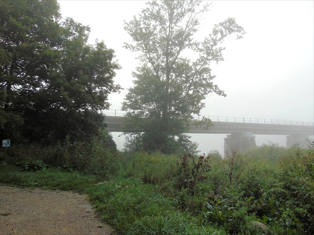
God's creation, along with man-made structures, make for a beautiful world to take walks and photos in. As we were driving down King Street, to get to the Pioneer Tower where I wanted to start on the Walter Bean Grand River Trail from, we were approaching the Freeport Bridge. Jan said she would love to stop at the bridge and get some photos and I wholeheartedly agreed that it would be a perfect morning to do that.
There is a parking lot there, and after parking I grabbed my cane, because the ground was too uneven to take my walker, and started toward the river and the bridge. The sun was trying to get through the thick fog, and you will get to see, along with me, some beauty that is seen when the fog blots out some of the less desirable things around you/me.
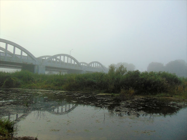
In the first photo, the bridges are reflected in the Grand River, as the water was quite calm at that time and place. {When I say bridges it is because there is a vehicle bridge and immediately beyond it is a railway bridge.} The green grasses and yellow flowers that you will see are showing beautifully through the fog.
The one thing I found when editing these photos was the urge to get rid of the haze as much as possible. That would have ruined them completely, so here goes. This picture was taken toward the Schneider Park area near the Grand River where it flows under the Freeport Bridge.
At one point I walked over to, and under the vehicle bridge. Here I was close to walking under it and you can see some graffiti on the abutments.
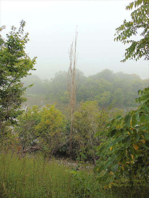
As I mentioned at the beginning of this writing, my photos are mixed up. This particular picture was taken near the Pioneer Tower, out over the Grand River.
A shot of the top of the tower taken in close from the path leading to the tower.
Above: Another shot of the bridge from a distance, and this time the daisies on the left-hand side are seen too.
Below: The beginning of the North end of the Bridge, with the whole bed of flowers in the foreground.
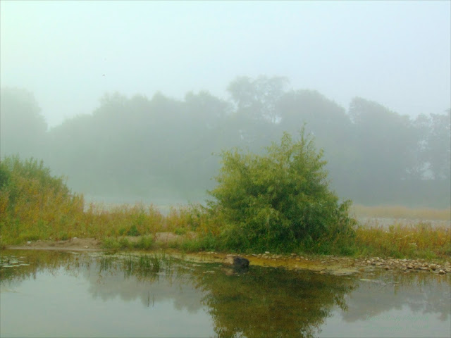
You can barely see the other side of the river due to the fog in this photo. However, the reflections are perfect here.
After I walked under the vehicle bridge I came to the spot where I could take a photo of the railway bridge. The fog is quite thick on this side of the white bridge.
By the time we got to the Pioneer Tower the fog was lifting some, and the grass was very wet. As I approached the tower from the parking spot, this is what I saw.
Above is the Conestoga Wagon weather vane in the fog that sits on top of the Pioneer Tower.
Another shot of the Foggy Grand River from behind the Pioneer Tower. This is taken from the top of the steep hill on which the tower is placed.
Above: You can see how wet the grass was by the tracks from my feet and walker coming across the grass by the Pioneer Tower. My feet were throughly soaked, but as it was already warming up I didn't mind the coolness of the wet.
Below: Another shot of the Grand River in the fog at the Freeport Bridge.
I just could not believe the reflections on the Grand River.
Another shot between the two bridges.
The fog is lifting but by doing so it is coming down as a mist. The wetness can be seen on the bottom edge of this plaque that is near the Pioneer Tower.
The fog is still hanging on over the Grand River behind the Pioneer Tower.
Some more photos of the fog on the river by the Freeport Bridge.
The railway bridge at Freeport.
Getting closer to the Pioneer Tower
The plaque and the Pioneer Tower.
The Pioneer Tower from the cemetery at the top of the steep hill.
Fog out over the grasses near Schneider Park at the Freeport Bridge.
At the Pioneer Tower.
This was how thick the fog was at King and Fairway on our way out to Doon.
A few minutes later at the Freeport Bridge.
Further down King as we headed out toward Freeport where we went and got photos of the river by the Freeport Bridge.
A sign at the Freeport Bridge.
Signage at the Schneider Park at Freeport. Here we decided to head along the trail that is shown on this sign and goes to the right there once we got to the Pioneer Tower and Kuntz Park.
Above: The entrance to Schneider Park and there is a garbage disposal unit right by the parking lot where we parked.
Below: More fog on the Grand River.
As I was coming back up from the river's edge, I saw this bush with pink flowers on it. I have no idea what kind of plant it is but just had to get some photos of it.
More fog photos.
Another shot of the pink flowers. There is a spider's web in there too.
The Walter Bean Grand River Trail that starts by the Pioneer Tower, and is down a steep trail with warnings of its steepness.
This one was taken partway down the hill and you can see where I'll have to trek back up when we return later.
Some of the scenery around the Pioneer Tower.
The beauty of green and yellow beside the Walter Bean Grand River Trail. It was here that I realized that I might have some difficulties because of my allergy to goldenrod. But I was not going to turn around and go back.
This was the trail that I, personally had wanted to take, but was also curious about the trail that we ended up taking.
You can get some idea how steep the incline is from the top of the trail here.
More beauty to the side of the trial.
This one is one I'm not sure where on the trail it was.
Back at the Pioneer tower there is a sign and I just had to take a photo of it.
This plaque is imbedded in the side of the Pioneer Tower.
Looking back to the parking lot and realizing this will be a stiff climb when we return. I just didn't have any idea how hot it would be in just over three hours when we arrived back here.
The entrance to the Pioneer Tower and you can see the plaque pictured earlier beside it.
Above: is the grassy area at the top of the cliff above the Grand River behind the Pioneer Tower.
Below is some more beautiful foliage along side the Walter Bean Grand River Trail. And more goldenrod.
At points there are trees on either side of the Walter Bean Grand River Trail, and here is one of those locations.
There is so much beauty to my left.
Coming around the back of the Pioneer Tower as I was heading toward the cliff edge.
Here I am finally down close to the end of the slope of the Walter Bean Grand River Trail that comes down from Lookout Lane, and the Pioneer Tower.
I love all the colours in this photo.
Here I got a glimpse of some water. It is a pond and has a lot of rushes/reeds around it on this side of it.
More fog ahead just off the trail.
A better glimpse of the pond.
In the distance you can see the Betzner Homestead.
More water showing through the reeds.
A hazy/foggy Pioneer Tower in the background.
Two trails. Which one do we take? We took the one to the left and found a lot of beauty. I will have to investigate the other one too as it is just a short distance in to its end, but I might get a better view of the pond that was peeking through in previous photos.
There are apple and fruit trees to the right and to the left of us.
Looking back toward the Pioneer Tower.
An apple tree in the background.
The Pioneer Tower in the distance. I really like my zoom camera.
When I took this picture of the apples I didn't know that the branches and apples were covered in dewdrops.
And then I can see the Grand River through the trees, just barely.
Even though you can't see it clearly, the Grand River is down that trail. Because I had my walker there was no way I was venturing in there.
More views of the Grand River.
And on down the Walter Bean Grand River Trail we travelled.
Another glimpse of the river.
As we travelled on the Walter Bean Grand River Trail, I began to wonder how much further it would be as I was beginning to feel the heat, even though the fog was not fully lifted, but the exercise of walking on a trail that also had other traffic as well was hard with the walker. I would not attempt this trail without my walker.
And the corn on the left went for a long way here.
And this is looking back to where we had come from.
A closeup of the corn at the edge and some weeds right at the edge of the trail.
At the other side of the trail is lots of goldenrod.
A real close look at the grasses.
I decided to take a selfie with some green in the background.
Above: Even though it is foggy, you can see a tree in the middle of this photo that is a different shade of green than the ones behind it.
Below: More greens and yellows beside the trail.
Just a few hundred feet more and it looks like the end of the trail is in view.
It is still foggy over the river area.
A zoomed shot of the green tree, and as I took that I noticed that there was some interesting colour in between me and the tree.
Now I can see the bridge on the right and it is basically the end of the Walter Bean Grand River Trail.
There are a number of plaques situated here.
Looking over to the bridge from the vicinity of the centre of the circle with the two green plaques in it.
A different angle of that green tree, and again more colourful foliage in the foreground.
Some more beautiful scenery.
Another selfie. This one was on the bridge with the Grand River behind me.
Above is the Grand River to the south of the bridge.
Below is a view right across the bridge from where I took the selfie.
This shot is to the north or right of the bridge from the end of the Walter Bean Grand River Trail.
You will see shots to the left and to the right alternately as I cross the bridge.
There were some seagulls and other birds on the opposite bank from where I stood when I took this one.
That branch intrigued me.
It is getting warmer and hazy as the fog lifts and the sun is trying to get through.
Some mallards that were on the edge of the river.
And a seagull all by himself.
There was a nice breeze on the bridge which made it more tolerable, even though it was getting quite hot.
Some of the scenery on the other side of the river, towards Conestoga College.
By this time I had crossed the bridge and debated if I wanted to explore further or turn around and return to the car.
A view up the river toward Doon.
The sun was trying so hard to come out.
Looking back across the river from this side of the bridge with the bridge in the picture.
Looking down river from where I was standing.
Looking down the trail that continues over to the area of Conestoga College.
Looking across the bridge from the west side. Although you can't really see them, there is a wasps nest in the corner by the no salt sign. I'm really glad I didn't go into that area to get some photos as I had planned.
Instead I had gone out a bit further and stood in a different crook of the railing.
Another shot of the bridge and river, this time from the spot I had chosen to take the photos from.
Looking down the trail yet again.
Capturing the rocks that ware right beside the trail.
Having decided to return to the car as by now it was getting really hot AND the sun was coming out more all the time, I took this shot before getting off the bridge.
And just as I did I saw these geese in the distance and took a couple of shots.
I think this one could be captioned, "Follow The Leader."
There was a Blue Heron standing on the rock pile on the west bank the whole time we were there. I got a lot fo shots of him, but this is the best and last one I took.
One lone goose. Must have missed the launch up river earlier when the rest of them took off.
The trail heading back to the car, and the sky is changing from gray to blue and white. YAY!!!
One more shot of the bridge and river here.
And the green tree doesn't stand out quite so much with the sunshine on it.
The circle at the end of the Walter Bean Grand River Trail, or you could call it the beginning as we head back to the car.
It is amazing how much difference 55 minutes can make in what a photo of the same spot can make. I have a shot of almost exactly the same spot 55 minutes earlier and this one is the type I prefer, without it being so hot though.
One more quick shot of the green tree.
There is beauty all around.
Even in a leaf that has blown onto the Walter Bean Grand River Trail.
The sun was still playing peek-a-boo.
Even the corn had more beauty with the sunshine.
And with the sunshine Jan notice the morning glory at the edge of the trail. I had seen it on our way out but the dimness of the foggy weather didn't make it appealing to take a picture of.
The sky, with the edge of the corn stalks made a beautiful picture.
I had to take a closeup of the ears of corn.
More beauty to the side of the Walter Bean Grand River Trail.
And even the beauty of the trail as it zigged ahead.
The edge of the corn field.
Another beautiful sky shot.
The river is yet again visible from here.
On the right hand side of the Walter Bean Grand River Trail, as we travelled back there was a tree with apples that I missed on the way out. Here is a closeup of the top of it.
A shot of the whole tree and a closeup of the fruit.
More scenery on either side of the Walter Bean Grand River Trail that was worth capturing with the sun shining on it.
A fog-free shot of the Pioneer Tower from the Walter Bean Grand River Trail.
From here you can see the Walter Bean Grand River Trail, as it winds up the steep slope toward the Pioneer Tower.
Behind me, as I took the last photo there was a bush and I loved the symmetry of the tree trunks and just had to take a photo.
As we approached the incline that took us the last 170metre/185.5 yd, I was able to get some good shots of the pond I'd spotted on the way out.
The sunshine made a world of difference about how it looked.
Just past the pond there was some shade and beside the trail there were some rocks piled.
This is looking up the Walter Bean Grand River Trail, toward the Pioneer Tower.
In the shade almost at the top I just had to sit down and relax for a minute or two. As I was sitting on my walker, I saw the trail to my left toward lookout point.
As I came back to the top, and Jan had gone on ahead to get the car, I quickly took two more photos of the Pioneer Tower. Now you can see the weather vane clearly against the blue sky.
I can hardly wait to go back out there but take the trail in the direction I originally intended to go, or come in from the Freeport Bridge end of it and then get a ride home. If I am seeing correctly, there is more possibility of shade that way than the Walter Bean Grand River Trail that we took. I will have to explore it and find out. Until next time, have a great day and enjoy trails or paths where you live.


Hi Anne!
ReplyDeleteIt was a pleasure meeting and talking with you today on the Avon Trail.
It seems our friend up in the tree across the river was an osprey. Enjoy your many journeys and I hope our paths cross again.
Tabi
Hi Tabi!
ReplyDeleteI really enjoyed our chat and I also discovered that he was an osprey. He took off soon after you left.
Annie